� From the Kitchen Table on McW | Main | Who Is The Star of This Show? �
July 18, 2004
Fire on the 14
My bros and I went hiking up Whitney Portal this morning. On the way back from a long and exhausting day, we got caught in the latest So Cal conflagration. 
We had sweated all last night having heard that the 14 had been closed. And since this fire is 'only' 14k acres and not a lot of people have lost their homes, there hasn't been much news coverage. Caltrans has absolutely nothing on their websites. We lucked out and heard something on KNX around 11pm which said that the 14 was open to through traffic, you just couldn't get off the freeway.
We hit the intersection above the Van Norman dam just about 7 this morning and I have never seen something so dramatic. At the top of the hill above that cascade for the California Aqueduct on the east side of the 405, flames were towering over 100 feet in the air. It was magnificent and awesome. There was a huge column of orange, rose and purpleish white smoke rising vertically like a smoking volcano or a thunderhead. A plume blew towards the south as the light winds over the hills disturbed the column at it's lower levels. A big Sikorsky passed right overhead to pick up a load of water from the reservoir to our immediate southwest.
As we swung around towards the 14, Deet got a couple shots of the rising sun turned blood red through the fog of brushfire smoke. It was beautiful and frightening. Heading northeast on the 14 we could see how the freeway had been an effective break. Everything on our right, to the south and up the mountain had been burnt to a crisp. An oilfield on the right was untouched.
It was on the way back that all of this started to cause trouble. Just a few minutes past Palmdale where the 14 swings from the North down to the West, the CHP was directing traffic off the freeway. At about 6:20pm we could see the cars slowing down and so we decided to get off early at Agua Dulce Road. We concluded that the fire had changed directions during the day and jumped back north over the 14. It was hard to imagine this happening, but as we got out to make some phone calls, the ashes were falling thickly like fat snowflakes. We were down to a quarter of a tank and out of cell phone range - a modern emergency in and of itself.
As the number of cars getting off at Agua Dulce increased, so did a palpable sense of panic. There was nobody there to show anyone where to go. Soon a Sheriff's deputy arrived on the scene and directed us to take Agua Dulce road north the Sierra Hwy and out. Any of you who have a Thomas Guide know how indespensible it is, unless you are on the border of its coverage area. In our case we were on the diagonal line that went inexplicably from page 4541 to 4281 to 4425 which was a different scale. In short, we were lost.
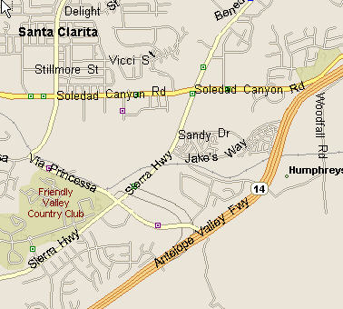
There was never much danger from the fire since we got off the 14 before the roadblock. But we languished in the cow country north of Vasquez Rocks for an interminable period as we watched the gas tank empty. Making the left turn onto Sierra Highway took 45 minutes with no CHP on the scene. By the time we got into Santa Clarita, we were plenty crabby. But then the sense of panic and disaster came back. At the intersection of Sierra and Soledad Canyon Roads, people were in that state of agitation we all recognize instinctively. Just south of us, four plumes of smoke were clearly visible just above houses on the hillsides. There were no helicopters in sight. Houses were going to burn right in front of us.

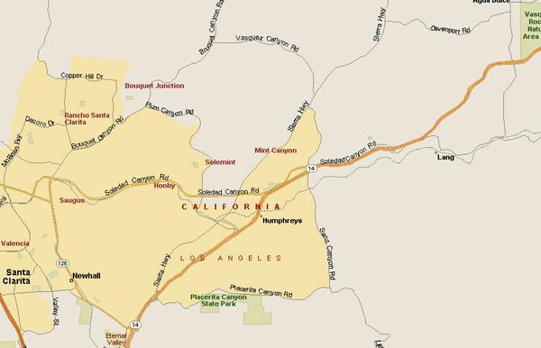
Filling up the Avalanche at the Mobil station, I tried to understand the logic of.. oh wait. There was a helicopter finally over to the east. Right over where Lang is shown on the map, I could see a red chopper making rounds. There were three columns of smoke over in that direction but we couldn't see flames. The flames were right in front of us up the hill near the Friendly Valley Country Club. People were moving their horses out of the area all over the place. But we figured those were goners. We drove through and became momentarily disoriented as we drove on. But eventually we got back on the 14 at what must have been Placerita Canyon. Doc says they don't fly the choppers at night, so folks up that way are in for a hell of a time.
I know the Angeles National Forest pretty well, so I got really tired of not hearing what part of it was burning. I thought you all might like to know as well.
Posted by mbowen at July 18, 2004 10:59 PM
Trackback Pings
TrackBack URL for this entry:
http://www.visioncircle.org/mt/mt-tb.cgi/2229
Comments
Thanks for the update. Now stay away from those flames, dadgummit!
Posted by: George at July 20, 2004 10:23 PM